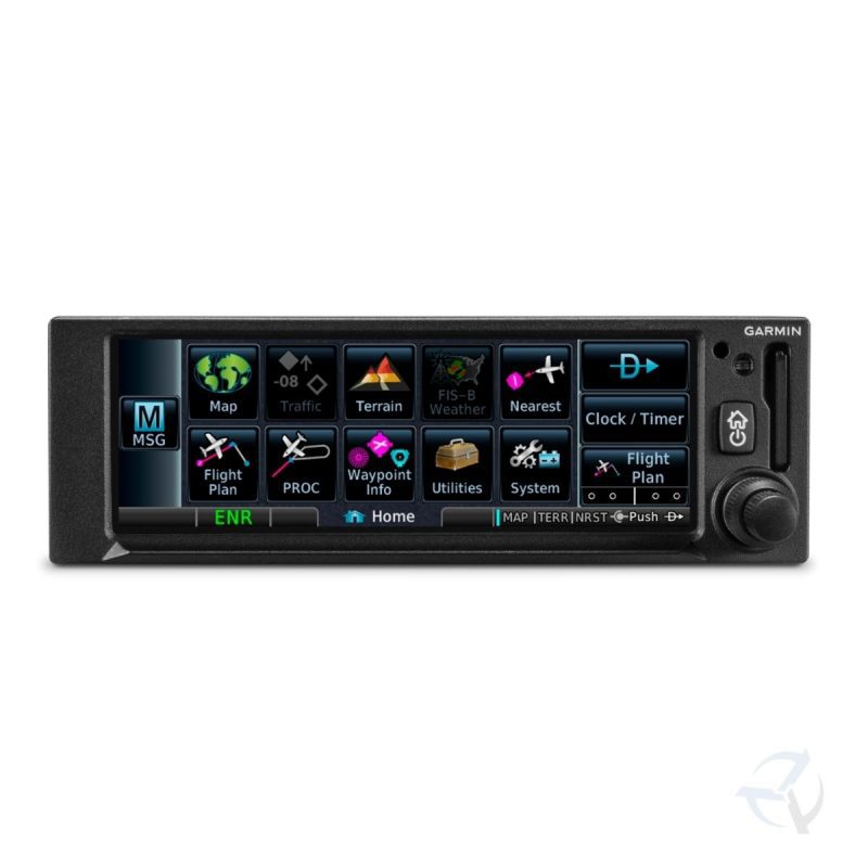


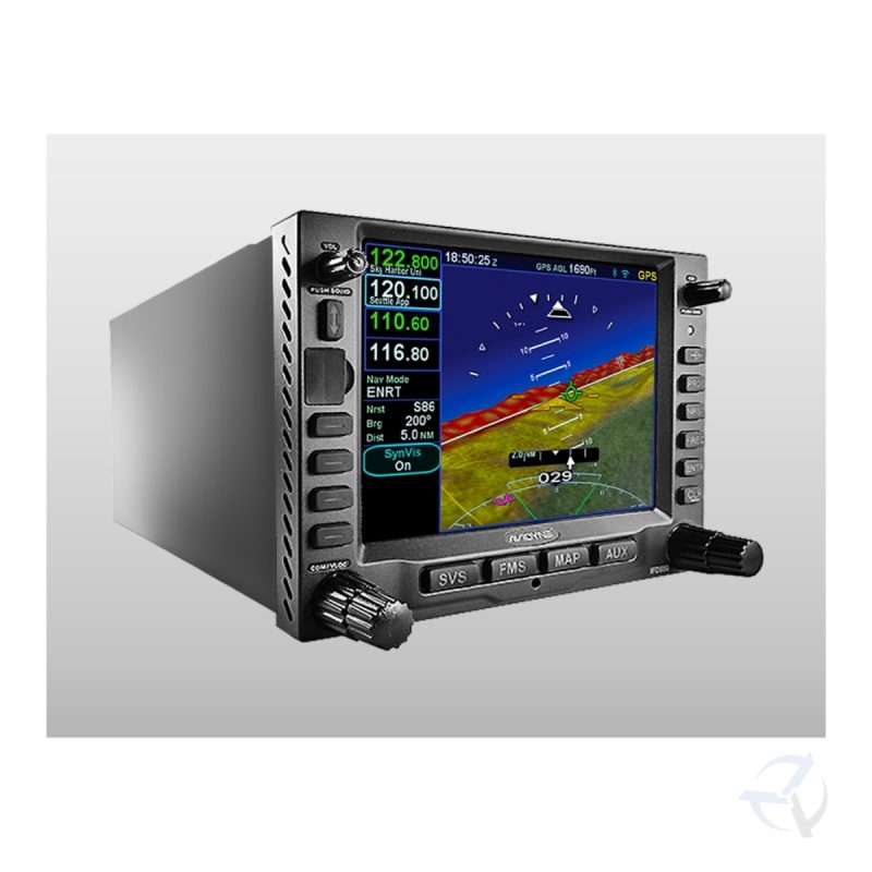
Garmin GTN™ 750Xi GPS/NAV/COMM/MFD
From $31,280.00
TAP INTO A NEW GENERATION OF FASTER, SMARTER AVIONICS
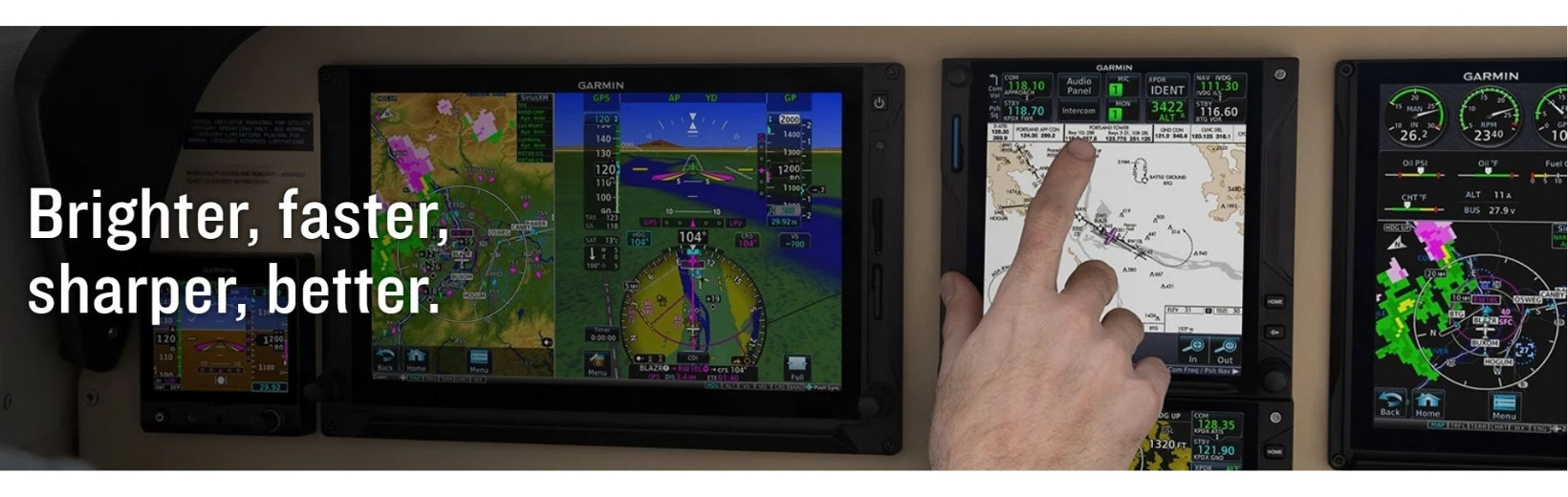
With more pixels, more processing power, more speed and performance, our GTN 750Xi system brings exciting new growth capabilities to the industry’s premier GPS/Nav/Comm/MFD platform.
This system must be installed by an Authorised Garmin Dealer or Service Centre.
Call (02) 9791 1137 for installation support into Amateur Built Aircraft.
Recent Part Number Changes – Now 010-02002-05
Out of stock
TAP INTO A NEW GENERATION OF FASTER, SMARTER AVIONICS
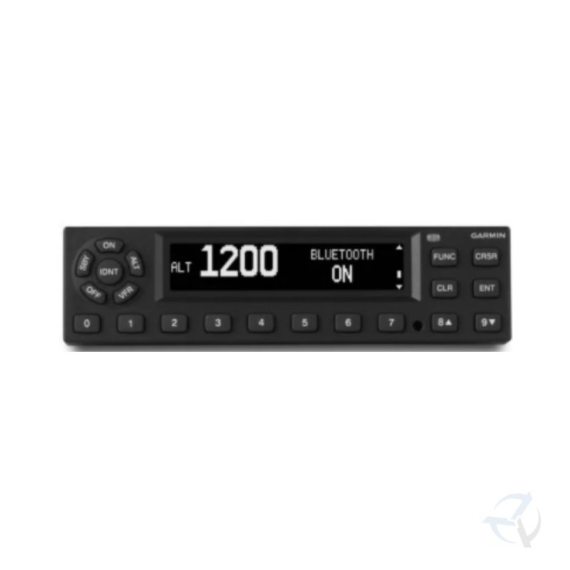
With more pixels, more processing power, more speed and performance, our GTN 650Xi system brings exciting new growth capabilities to the industry’s premier GPS/Nav/Comm/MFD platform.

Visualize your entire flight plan, including holds and approaches on a big 4.9” touch display.
|

Faster is better. High-speed processors cut boot-up time by 50% over earlier GTN models.
|

Fly the approaches you want — from visual glidepaths to LPV, RNAV, ILS and more.
|

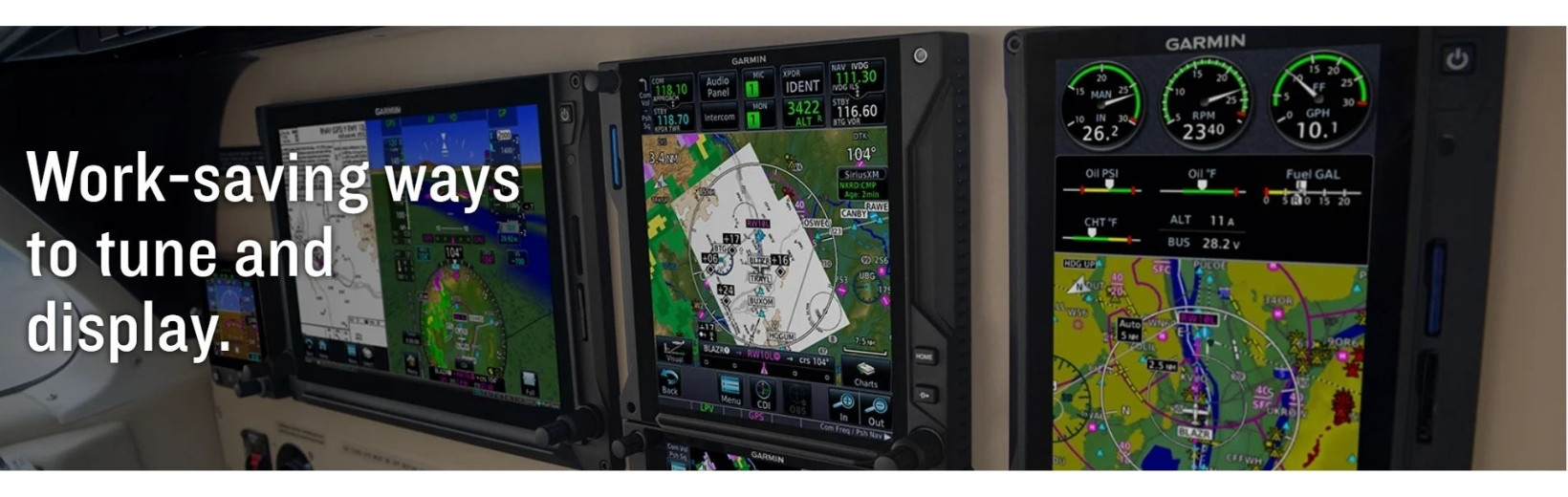
It’s interface-friendly with a wide range of existing avionics, autopilots and flight displays.
|

Wirelessly load flight plans and database updates with an optional Connext® link.
|

Upgrade? New GTN Xi series offers easy slide-in upgrade for existing GTN avionics.
|
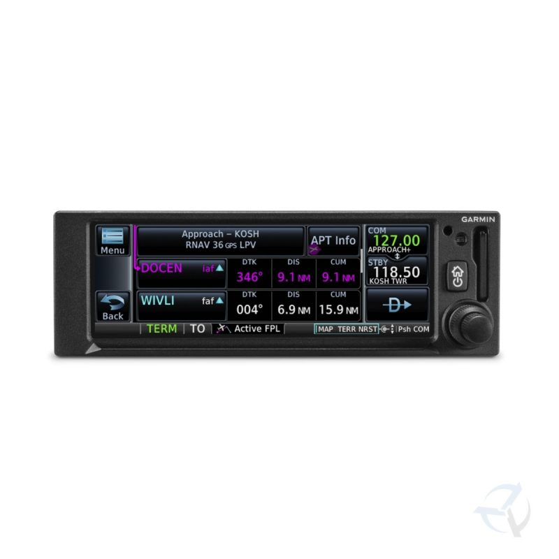
DO-IT-ALL TOUCHSCREENIntuitive touchscreen interface provides quick access to navigation, radio tuning, multifunction display features and more.
|
LIGHTNING-FAST RESPONSEPowerful dual-core processors boost the GTN Xi series graphical display capabilities — with faster zooming, panning and map rendering on the display.
|
HIGH-RESOLUTION DISPLAYWith almost double the pixel count of its predecessor, the GTN Xi series features wider viewing angles and one of the highest-resolution displays ever offered in this class of avionics.
|
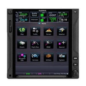
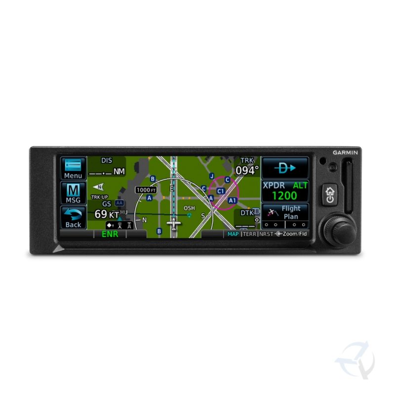
MULTIFUNCTION DISPLAYSupporting multiple inputs, the 6.9” display can put moving maps, terrain, traffic2, weather2, airport diagrams and more at your fingertips.
|

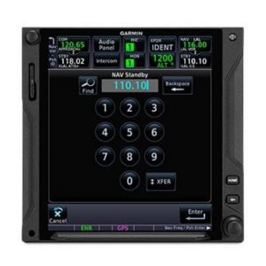
EASY DATA ENTRYUse the on-screen QWERTY keyboard or traditional concentric knobs to enter frequencies, waypoint identifiers, routings and more.
|
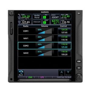
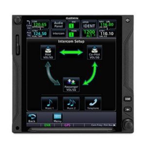
REMOTE RADIO CONTROLIn dual GTN Xi installations, remote tuning capability lets you tune frequencies on both units from either navigator. A Radios page displays all selectable Comm and Nav frequencies (active and standby) plus their volume levels.
|
TELL IT, TUNE ITAvailable Telligence™ voice control technology helps reduce pilot workload by responding to hundreds of spoken commands with the press of a button on the yoke2.
|
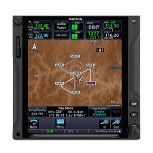
PINCH, SWIPE GESTURESA quick finger swipe lets you pan across the map display. Or use a smartphone-like pinch-to-zoom motion to scale up or down on any map, traffic or terrain page.
|
QUICK PAGE ACCESS VIA KNOBSThe unit’s dual concentric knob controls now offer quick access to select pages. The outer knob can cycle through as many as 9 custom-assigned pages, with the inner knob supporting functions such as zooming or scrolling on the page displayed.
|
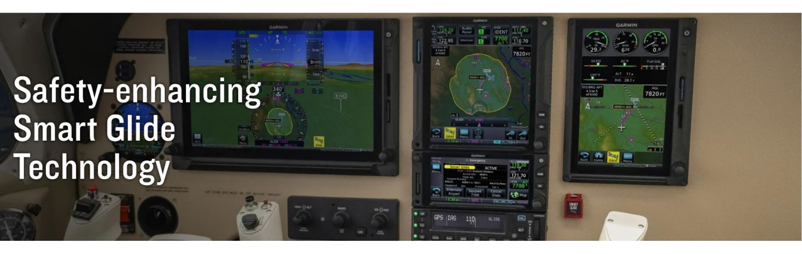
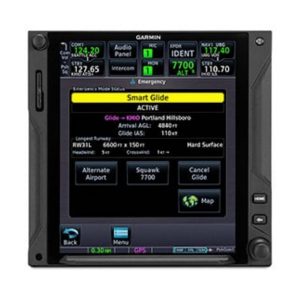
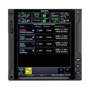
ENGINE-OUT HELPIn the case of an engine power loss situation, GTN Xi offers Smart Glide technology to help reduce your workload — so you can focus more attention on other tasks during the emergency.
|
EASY ACTIVATIONSmart Glide requires a compatible flight display to be paired with GTN Xi. The Smart Glide system can be activated with the press of an optional dedicated panel button or by a long press of the Direct-to button.
|
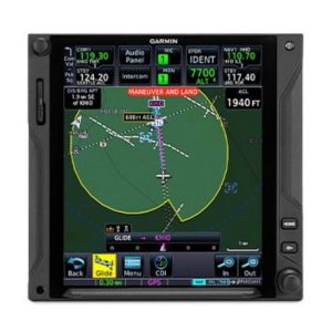
RECOMMENDS AN AIRPORTConsidering the aircraft’s estimated glide range (including terrain and obstacles), the system recommends a suitable airport for landing and offers a list of alternatives, or it advises if no airport is estimated to be within glide range.
|
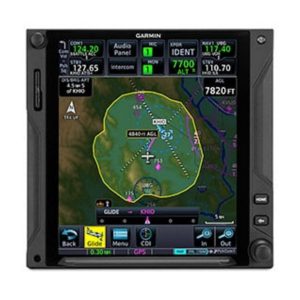
DIRECT-TO ROUTINGIf an airport is available, it creates a Direct-to route to the selected airport. And if you’re equipped with a compatible Garmin autopilot, Smart Glide will automatically engage the autopilot in IAS mode at best glide speed — using the GPS guidance to fly the aircraft near the selected airport.
|
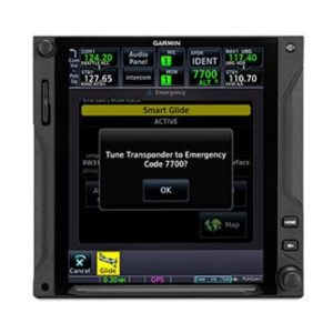
EMERGENCY INFORMATIONSmart Glide provides information for the selected airport and loads the airport CTAF frequency into the GTN Xi standby position while providing a shortcut to enter an emergency code in a compatible transponder.
|
LANDINGOnce the aircraft is near the airport, the pilot resumes control and prepares the aircraft for arrival — for example, bleeding off altitude and making the final approach to the selected runway — then lands the aircraft.
|

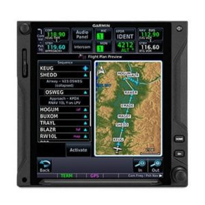
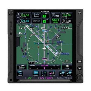
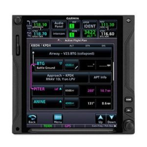
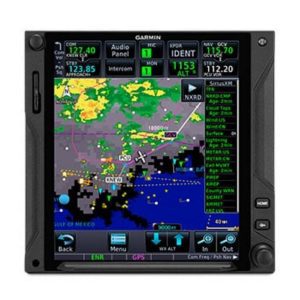
SEE THE FULL PICTUREGraphical routing on the display lets you visualize your entire flight plan, including departures, arrivals, visual/instrument approaches, holding procedures and more.
|
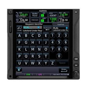
FAST FINDAs soon as you start typing, the GTN Xi FastFind feature uses quick predictive logic to suggest airport and waypoint entries by using current GPS position. Just select and go.
|
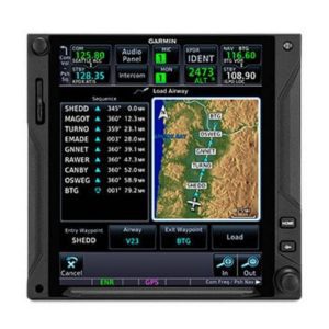
AIRWAYS, YOUR WAYVictor airways and high-altitude jet routes can be overlaid on the map. For easy IFR routings, view airway segments available from a waypoint and corresponding exit options.
|
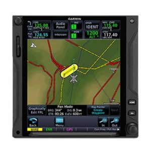
“RUBBER BAND” REROUTESThis handy feature lets you grab a flight plan leg on the screen, and then stretch or move it to adjust for a deviation or ATC amendment to your flight plan.
|
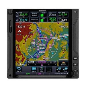
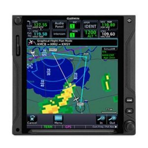
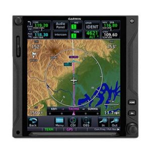
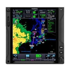
VIRTUAL MAP TOPOGRAPHYBy referencing built-in terrain, mapping and obstacles databases, GTN 750Xi shows detailed surface features, cities, airports, SUAs and more on the dynamic map display.
|
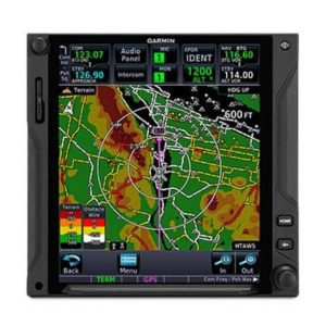
TERRAIN ALERTINGA built-in database provides color-coded display overlays to warn when potential terrain conflicts loom ahead. Class A or B TAWS alerting is optionally available.
|
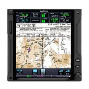
VIEW CHARTS IN CONTEXTOur standard FliteCharts® or optional Jeppesen® style ChartView™ plates3 provide georeferenced approaches and terminal procedures.
|
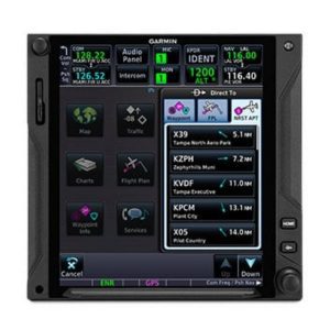
DIRECT CONNECTA Direct-to key on the bezel lets you quickly enter a direct course for any selected waypoint. A menu of nearest airports and flight plan waypoints makes for easy entry.
|
|

MORE APPROACH OPTIONSThe WAAS/SBAS-certified GPS receiver expands your landing options, enabling GPS-guided LPV glidepath approaches down to ILS-comparable minimums as low as 200’.
|
VHF NAVAID CAPABILITYIn addition to GPS guidance, full VHF navigation capabilities offer complete airspace system access, including VOR/ILS with localizer and glideslope.
|
AUTO-ASSIST ENTRYWhen loading procedures, the GTN Xi series will pre-enter NAV frequencies to standby position for quick access. It also auto-selects the VHF NAV source for ILS approaches.
|
CLEARED FOR THE VISUALGTN Xi can give advisory visual approach guidance based on a published glidepath or a 3-degree slope from the runway threshold (with terrain/obstacle clearance).
|
AUTOPILOT INTERFACEPrecise course deviation and roll steering outputs can be coupled to select autopilots, enabling virtually all IFR flight procedures to be flown automatically.
|
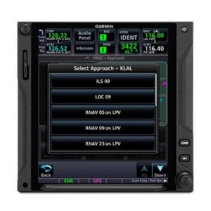
HOLDING PATTERNSIFR pattern entries can be tricky. GTN 750Xi lets you easily create and execute holding patterns over a published or user-defined waypoint.
|
SEARCH AND RESCUEFor aerial surveillance, common search pattern types — including orbit, parallel line, expanding square and sector search — can be loaded into your flight plan on the GTN 750Xi navigator2.
|
SUPPORTS VNAV AND MOREWith our GFC™ 500 and GFC 600, GTN 750Xi supports advanced modes and features such as vertical navigation profiles, radius-to-fix legs, missed approaches and more.
|
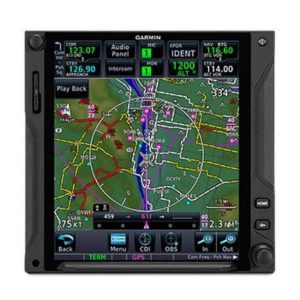
SAFETAXI® DATABASEUpon landing, georeferenced SafeTaxi diagrams on the display automatically help track your location on hundreds of airports.
|

BUILT-IN COMM TRANSCEIVERA 2,280-channel capable VHF Comm radio gives GTN 750Xi a standard 10 watts (or optional 16 watts) of talking power with pilot-selectable 25 kHz or 8.33 kHz channel spacing.
|
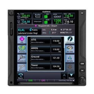
FIND A FREQUENCYA work-saving lookup function lets you enter any navaid or airport identifier and have the GTN Xi navigator look up the frequencies for that location (tower, ground, ATIS, clearance delivery, etc.). You can then tap to send the frequency to any radio slot.
|
SPACE-SAVING AUDIOTo streamline your avionics stack, GTN 750Xi can double as the control panel for your audio system when it’s paired with one of our GMA™ 35 remote audio units (sold separately).
|
INSTANT RECALLGTN Xi database technology allows you to quickly recall your most frequently or recently used frequencies. Plus, holding down the volume knob will dial up the emergency frequency.
|
STATION CONFIRMATIONIf you’re given a frequency by ATC, our GTN Xi lookup function will automatically provide the station identifier right below it. So you’ll know you’re making the right call.
|
|
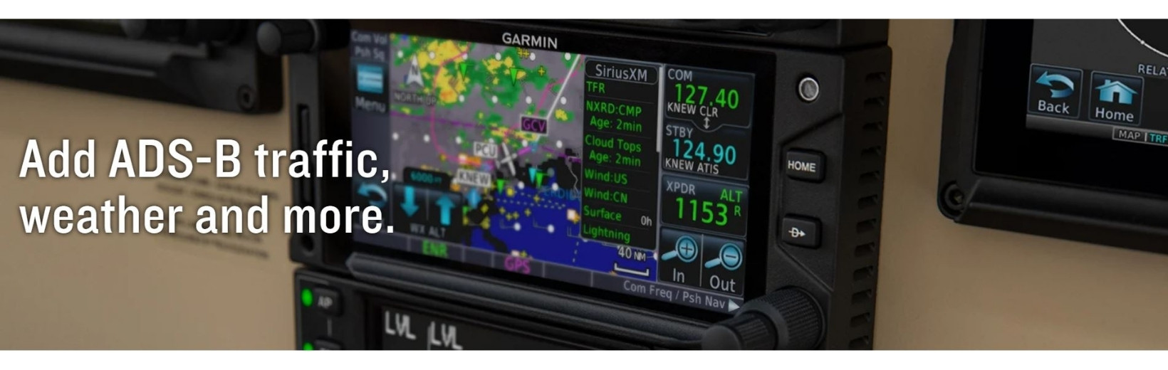
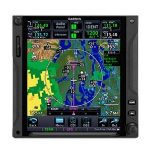
ADS-B DATA LINKSWith available Garmin ADS-B “In” equipage solutions, GTN 750Xi can display up to 60 ADS-B traffic targets as well as subscription-free U.S. weather data.
|
TARGETTREND™ TRACKINGADS-B based TargetTrend relative motion tracking on the GTN Xi display gives pilots a faster, more intuitive way of judging traffic closure rates and trajectories.
|
TERMINALTRAFFIC™ DISPLAYProviding a dynamic display of ADS-B-equipped aircraft and ground vehicles, this technology helps pilots avoid traffic conflicts within the airport environment.
|
ACTIVE TRAFFIC SOLUTIONSFor more advanced traffic surveillance capability, GTN Xi can integrate with select TAS or TCAS/ACAS systems, including our GTS™ family of ADS-B enhanced products.
|
SIRIUSXM® SERVICEWhen paired with an optional GDL® 69 datalink receiver, GTN Xi can incorporate SiriusXM satellite weather coverage — plus audio entertainment features4.
|
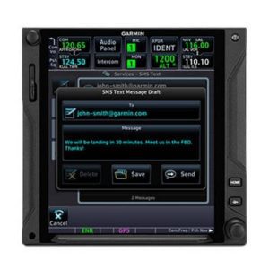
WORLDWIDE COMMUNICATIONSWant global weather, radar imagery and two-way text/voice communications from the air? Connect your GTN 750Xi with our optional GSR 56 satellite link4.
|
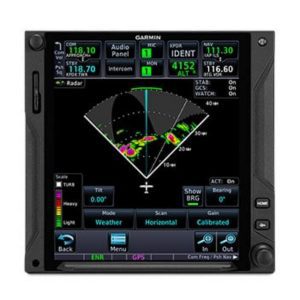
ONBOARD RADARTo scan your own storm cells, the large-format GTN 750Xi can double as a display for our Doppler-capable GWX™ 75 series digital weather radars — as well as select third-party radar systems6.
|
|
|

CONNECTED COCKPITUse optional Connext technology to stream information between GTN Xi and compatible Garmin portables or mobile devices running the Garmin Pilot™ or FltPlan Go apps5.
|
FLIGHT PLAN TRANSFERSave time by creating your flight plan on your mobile device at home, then use Connext2 to wirelessly upload the data into your GTN Xi during preflight at the airport.
|
FLIGHT STREAMIn addition to GPS data, a compatible Connext wireless gateway5 can stream ADS-B traffic, weather and backup attitude data to your mobile device in real time2.
|
DATABASE SYNCA Flight Stream 510 Connext gateway5 adds Database Concierge to your GTN Xi navigator. Upload databases from your tablet in minutes — then let automatic sync with your avionics do the rest.
|
|
|

HELICOPTER OPTIMIZATIONFor demanding helicopter missions, optional GTN 750Xi versions are available with an NVG-compatible display and some 200,000 more low-altitude obstacles in the database.
|
POWER LINE DATAFor added protection and visual reference in low-level flight conditions, an expanded GTN Xi helicopter database includes more than 700,000 miles of power lines.
|
WIREAWARE™ TECHNOLOGYUsing the expanded helicopter database, WireAware helps pilots recognize wire-strike hazards with proximity alerts and power lines displayed on the GTN Xi moving map.
|
HTAWS ALERTINGOptional HTAWS provides GTN Xi with audible alerting and five-color map shading to highlight nearby terrain, obstacles and wires — with voice callouts on descent below 500’.
|
RADAR ALTIMETERWhen paired with a GRA™ 55 radar altimeter5, GTN Xi can be used to track terrain clearance, displaying precise AGL altitude with HTAWS alerting down to 50’.
|
ON-SCENE MODEIn scenarios such as electronic news gathering, where it’s necessary to hover in proximity to other helicopters, On-scene mode lets pilots minimize repeat alerts for traffic they’re aware of.
|
- TSO applicability: C34e; 2C34f; C36e Class A; 2C36f Class A; C40c; 2C40c; C74d Class A; C112e; C128a; 2C128; C146e Class 3; C151d Class A, B; C157b Class 1, 2; 165b; C169a Class C, E, 3, 4, 5, 6; 2C169a Class C, E, H2, 3, 4, 5, 6; C194; C195b Class B1, B3, B5, B7; C209
- Display size: 6.9″ (175 mm) diagonal
- Display resolution: 834 pixels (W) x 986 pixels (H)
- Unit bezel height: 6.00″ (152 mm)
- Unit bezel width: 6.25″ (159 mm)
- Unit depth with connectors: 11.25″ (286 mm) (measured from face of aircraft panel to rear of connector backshells)
- Unit weight: 7.1 lbs (3.22 kg)
- Input voltage range: 11 VDC – 33 VDC
- Operating temperature range: -20° C to 55° C (-4° F to 131° F)
- Number of GPS channels: 15 (12 GPS and 3 GPS/WAAS/SBAS)
- LAT/LON position accuracy: <1.25 meter RMS horizontal, < 2 meter vertical, with WAAS
- Maximum velocity: 1,166 knots
- Position update Interval: 0.2 sec (5 Hz)
- GTN 750Xi receiver
- Rack
- Backplate
- Connector kit
- Configuration Module
- Product information kit
Does not include: Database Card or GA 35 WAAS Antenna in the above, can be ordered additionally.
- GA 35 WAAS GPS Antenna – (013-00235-00)
- NAV DataBase – INT’L (010-02044-20), Worldwide (010-02044-30) – (NavData, Terrain, Obstacle, FliteCharts, SafeTaxi)
- Flight Stream 510 – (010-01322-01)
For more information, specifications and product details please visit the official Garmin website.
Reviews
There are no reviews yet.
You may also like…
Garmin GTN™ 750Xi GPS/NAV/COMM/MFD
From $31,280.00
TAP INTO A NEW GENERATION OF FASTER, SMARTER AVIONICS
With more pixels, more processing power, more speed and performance, our GTN 750Xi system brings exciting new growth capabilities to the industry’s premier GPS/Nav/Comm/MFD platform.
This system must be installed by an Authorised Garmin Dealer or Service Centre.
Call (02) 9791 1137 for installation support into Amateur Built Aircraft.
Recent Part Number Changes – Now 010-02002-05
TAP INTO A NEW GENERATION OF FASTER, SMARTER AVIONICS
With more pixels, more processing power, more speed and performance, our GTN 650Xi system brings exciting new growth capabilities to the industry’s premier GPS/Nav/Comm/MFD platform.
|
Visualize your entire flight plan, including holds and approaches on a big 4.9” touch display.
|
Faster is better. High-speed processors cut boot-up time by 50% over earlier GTN models.
|
Fly the approaches you want — from visual glidepaths to LPV, RNAV, ILS and more.
|
It’s interface-friendly with a wide range of existing avionics, autopilots and flight displays.
|
Wirelessly load flight plans and database updates with an optional Connext® link.
|
Upgrade? New GTN Xi series offers easy slide-in upgrade for existing GTN avionics.
|
DO-IT-ALL TOUCHSCREENIntuitive touchscreen interface provides quick access to navigation, radio tuning, multifunction display features and more.
|
LIGHTNING-FAST RESPONSEPowerful dual-core processors boost the GTN Xi series graphical display capabilities — with faster zooming, panning and map rendering on the display.
|
HIGH-RESOLUTION DISPLAYWith almost double the pixel count of its predecessor, the GTN Xi series features wider viewing angles and one of the highest-resolution displays ever offered in this class of avionics.
|
MULTIFUNCTION DISPLAYSupporting multiple inputs, the 6.9” display can put moving maps, terrain, traffic2, weather2, airport diagrams and more at your fingertips.
|
EASY DATA ENTRYUse the on-screen QWERTY keyboard or traditional concentric knobs to enter frequencies, waypoint identifiers, routings and more.
|
REMOTE RADIO CONTROLIn dual GTN Xi installations, remote tuning capability lets you tune frequencies on both units from either navigator. A Radios page displays all selectable Comm and Nav frequencies (active and standby) plus their volume levels.
|
TELL IT, TUNE ITAvailable Telligence™ voice control technology helps reduce pilot workload by responding to hundreds of spoken commands with the press of a button on the yoke2.
|
PINCH, SWIPE GESTURESA quick finger swipe lets you pan across the map display. Or use a smartphone-like pinch-to-zoom motion to scale up or down on any map, traffic or terrain page.
|
QUICK PAGE ACCESS VIA KNOBSThe unit’s dual concentric knob controls now offer quick access to select pages. The outer knob can cycle through as many as 9 custom-assigned pages, with the inner knob supporting functions such as zooming or scrolling on the page displayed.
|
ENGINE-OUT HELPIn the case of an engine power loss situation, GTN Xi offers Smart Glide technology to help reduce your workload — so you can focus more attention on other tasks during the emergency.
|
EASY ACTIVATIONSmart Glide requires a compatible flight display to be paired with GTN Xi. The Smart Glide system can be activated with the press of an optional dedicated panel button or by a long press of the Direct-to button.
|
RECOMMENDS AN AIRPORTConsidering the aircraft’s estimated glide range (including terrain and obstacles), the system recommends a suitable airport for landing and offers a list of alternatives, or it advises if no airport is estimated to be within glide range.
|
DIRECT-TO ROUTINGIf an airport is available, it creates a Direct-to route to the selected airport. And if you’re equipped with a compatible Garmin autopilot, Smart Glide will automatically engage the autopilot in IAS mode at best glide speed — using the GPS guidance to fly the aircraft near the selected airport.
|
EMERGENCY INFORMATIONSmart Glide provides information for the selected airport and loads the airport CTAF frequency into the GTN Xi standby position while providing a shortcut to enter an emergency code in a compatible transponder.
|
LANDINGOnce the aircraft is near the airport, the pilot resumes control and prepares the aircraft for arrival — for example, bleeding off altitude and making the final approach to the selected runway — then lands the aircraft.
|
SEE THE FULL PICTUREGraphical routing on the display lets you visualize your entire flight plan, including departures, arrivals, visual/instrument approaches, holding procedures and more.
|
FAST FINDAs soon as you start typing, the GTN Xi FastFind feature uses quick predictive logic to suggest airport and waypoint entries by using current GPS position. Just select and go.
|
AIRWAYS, YOUR WAYVictor airways and high-altitude jet routes can be overlaid on the map. For easy IFR routings, view airway segments available from a waypoint and corresponding exit options.
|
“RUBBER BAND” REROUTESThis handy feature lets you grab a flight plan leg on the screen, and then stretch or move it to adjust for a deviation or ATC amendment to your flight plan.
|
VIRTUAL MAP TOPOGRAPHYBy referencing built-in terrain, mapping and obstacles databases, GTN 750Xi shows detailed surface features, cities, airports, SUAs and more on the dynamic map display.
|
TERRAIN ALERTINGA built-in database provides color-coded display overlays to warn when potential terrain conflicts loom ahead. Class A or B TAWS alerting is optionally available.
|
VIEW CHARTS IN CONTEXTOur standard FliteCharts® or optional Jeppesen® style ChartView™ plates3 provide georeferenced approaches and terminal procedures.
|
DIRECT CONNECTA Direct-to key on the bezel lets you quickly enter a direct course for any selected waypoint. A menu of nearest airports and flight plan waypoints makes for easy entry.
|
|
MORE APPROACH OPTIONSThe WAAS/SBAS-certified GPS receiver expands your landing options, enabling GPS-guided LPV glidepath approaches down to ILS-comparable minimums as low as 200’.
|
VHF NAVAID CAPABILITYIn addition to GPS guidance, full VHF navigation capabilities offer complete airspace system access, including VOR/ILS with localizer and glideslope.
|
AUTO-ASSIST ENTRYWhen loading procedures, the GTN Xi series will pre-enter NAV frequencies to standby position for quick access. It also auto-selects the VHF NAV source for ILS approaches.
|
CLEARED FOR THE VISUALGTN Xi can give advisory visual approach guidance based on a published glidepath or a 3-degree slope from the runway threshold (with terrain/obstacle clearance).
|
AUTOPILOT INTERFACEPrecise course deviation and roll steering outputs can be coupled to select autopilots, enabling virtually all IFR flight procedures to be flown automatically.
|
HOLDING PATTERNSIFR pattern entries can be tricky. GTN 750Xi lets you easily create and execute holding patterns over a published or user-defined waypoint.
|
SEARCH AND RESCUEFor aerial surveillance, common search pattern types — including orbit, parallel line, expanding square and sector search — can be loaded into your flight plan on the GTN 750Xi navigator2.
|
SUPPORTS VNAV AND MOREWith our GFC™ 500 and GFC 600, GTN 750Xi supports advanced modes and features such as vertical navigation profiles, radius-to-fix legs, missed approaches and more.
|
SAFETAXI® DATABASEUpon landing, georeferenced SafeTaxi diagrams on the display automatically help track your location on hundreds of airports.
|
BUILT-IN COMM TRANSCEIVERA 2,280-channel capable VHF Comm radio gives GTN 750Xi a standard 10 watts (or optional 16 watts) of talking power with pilot-selectable 25 kHz or 8.33 kHz channel spacing.
|
FIND A FREQUENCYA work-saving lookup function lets you enter any navaid or airport identifier and have the GTN Xi navigator look up the frequencies for that location (tower, ground, ATIS, clearance delivery, etc.). You can then tap to send the frequency to any radio slot.
|
SPACE-SAVING AUDIOTo streamline your avionics stack, GTN 750Xi can double as the control panel for your audio system when it’s paired with one of our GMA™ 35 remote audio units (sold separately).
|
INSTANT RECALLGTN Xi database technology allows you to quickly recall your most frequently or recently used frequencies. Plus, holding down the volume knob will dial up the emergency frequency.
|
STATION CONFIRMATIONIf you’re given a frequency by ATC, our GTN Xi lookup function will automatically provide the station identifier right below it. So you’ll know you’re making the right call.
|
|
ADS-B DATA LINKSWith available Garmin ADS-B “In” equipage solutions, GTN 750Xi can display up to 60 ADS-B traffic targets as well as subscription-free U.S. weather data.
|
TARGETTREND™ TRACKINGADS-B based TargetTrend relative motion tracking on the GTN Xi display gives pilots a faster, more intuitive way of judging traffic closure rates and trajectories.
|
TERMINALTRAFFIC™ DISPLAYProviding a dynamic display of ADS-B-equipped aircraft and ground vehicles, this technology helps pilots avoid traffic conflicts within the airport environment.
|
ACTIVE TRAFFIC SOLUTIONSFor more advanced traffic surveillance capability, GTN Xi can integrate with select TAS or TCAS/ACAS systems, including our GTS™ family of ADS-B enhanced products.
|
SIRIUSXM® SERVICEWhen paired with an optional GDL® 69 datalink receiver, GTN Xi can incorporate SiriusXM satellite weather coverage — plus audio entertainment features4.
|
WORLDWIDE COMMUNICATIONSWant global weather, radar imagery and two-way text/voice communications from the air? Connect your GTN 750Xi with our optional GSR 56 satellite link4.
|
ONBOARD RADARTo scan your own storm cells, the large-format GTN 750Xi can double as a display for our Doppler-capable GWX™ 75 series digital weather radars — as well as select third-party radar systems6.
|
|
|
CONNECTED COCKPITUse optional Connext technology to stream information between GTN Xi and compatible Garmin portables or mobile devices running the Garmin Pilot™ or FltPlan Go apps5.
|
FLIGHT PLAN TRANSFERSave time by creating your flight plan on your mobile device at home, then use Connext2 to wirelessly upload the data into your GTN Xi during preflight at the airport.
|
FLIGHT STREAMIn addition to GPS data, a compatible Connext wireless gateway5 can stream ADS-B traffic, weather and backup attitude data to your mobile device in real time2.
|
DATABASE SYNCA Flight Stream 510 Connext gateway5 adds Database Concierge to your GTN Xi navigator. Upload databases from your tablet in minutes — then let automatic sync with your avionics do the rest.
|
|
|
HELICOPTER OPTIMIZATIONFor demanding helicopter missions, optional GTN 750Xi versions are available with an NVG-compatible display and some 200,000 more low-altitude obstacles in the database.
|
POWER LINE DATAFor added protection and visual reference in low-level flight conditions, an expanded GTN Xi helicopter database includes more than 700,000 miles of power lines.
|
WIREAWARE™ TECHNOLOGYUsing the expanded helicopter database, WireAware helps pilots recognize wire-strike hazards with proximity alerts and power lines displayed on the GTN Xi moving map.
|
HTAWS ALERTINGOptional HTAWS provides GTN Xi with audible alerting and five-color map shading to highlight nearby terrain, obstacles and wires — with voice callouts on descent below 500’.
|
RADAR ALTIMETERWhen paired with a GRA™ 55 radar altimeter5, GTN Xi can be used to track terrain clearance, displaying precise AGL altitude with HTAWS alerting down to 50’.
|
ON-SCENE MODEIn scenarios such as electronic news gathering, where it’s necessary to hover in proximity to other helicopters, On-scene mode lets pilots minimize repeat alerts for traffic they’re aware of.
|
- TSO applicability: C34e; 2C34f; C36e Class A; 2C36f Class A; C40c; 2C40c; C74d Class A; C112e; C128a; 2C128; C146e Class 3; C151d Class A, B; C157b Class 1, 2; 165b; C169a Class C, E, 3, 4, 5, 6; 2C169a Class C, E, H2, 3, 4, 5, 6; C194; C195b Class B1, B3, B5, B7; C209
- Display size: 6.9″ (175 mm) diagonal
- Display resolution: 834 pixels (W) x 986 pixels (H)
- Unit bezel height: 6.00″ (152 mm)
- Unit bezel width: 6.25″ (159 mm)
- Unit depth with connectors: 11.25″ (286 mm) (measured from face of aircraft panel to rear of connector backshells)
- Unit weight: 7.1 lbs (3.22 kg)
- Input voltage range: 11 VDC – 33 VDC
- Operating temperature range: -20° C to 55° C (-4° F to 131° F)
- Number of GPS channels: 15 (12 GPS and 3 GPS/WAAS/SBAS)
- LAT/LON position accuracy: <1.25 meter RMS horizontal, < 2 meter vertical, with WAAS
- Maximum velocity: 1,166 knots
- Position update Interval: 0.2 sec (5 Hz)
- GTN 750Xi receiver
- Rack
- Backplate
- Connector kit
- Configuration Module
- Product information kit
Does not include: Database Card or GA 35 WAAS Antenna in the above, can be ordered additionally.
- GA 35 WAAS GPS Antenna – (013-00235-00)
- NAV DataBase – INT’L (010-02044-20), Worldwide (010-02044-30) – (NavData, Terrain, Obstacle, FliteCharts, SafeTaxi)
- Flight Stream 510 – (010-01322-01)
For more information, specifications and product details please visit the official Garmin website.
Reviews
There are no reviews yet.
Reviews
There are no reviews yet.